| Price PP: | $353 |
| Lowest Price Guarantee | |
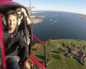
What landmarks will I see during a scenic flight over Baltimore?
On a Baltimore scenic flight, you can expect sweeping aerial views of the famous Inner Harbor, the downtown skyline, and historic waterfront areas. Many routes also showcase :contentReference[oaicite:0]{index=0}, where the U.S. national anthem was inspired, as well as panoramic views of :contentReference[oaicite:1]{index=1} and the surrounding coastal landscape. Depending on your route, you may also see sports stadiums, marinas, and key city bridges from above.
How long do scenic flights in Baltimore usually last?
Flight durations typically range from short introductory experiences of around 15–20 minutes to more extended tours lasting 45–60 minutes or more. Shorter flights focus on downtown Baltimore highlights, while longer routes expand out toward the bay and surrounding shoreline for a broader aerial experience.
Where do Baltimore scenic flights depart from?
Departure locations vary by operator, but most scenic flights in the Baltimore area operate from nearby regional airports or private airfields just outside the city. Your booking confirmation will specify the exact departure point, which is typically within easy reach of central Baltimore.
Is a scenic flight over Baltimore suitable for first-time flyers?
Yes, scenic flights are designed to be beginner-friendly and require no prior flying experience. Passengers simply board, receive a brief safety overview, and then relax while an experienced pilot handles the aircraft. It’s a smooth and accessible way to experience Baltimore from the sky for the first time.
What is the best time of day for a scenic flight in Baltimore?
Late afternoon and early evening flights are especially popular due to softer lighting and golden-hour views over the city and waterfront. Morning flights often offer clearer skies and calm conditions, providing excellent visibility of landmarks like the Inner Harbor and Chesapeake shoreline.
 Adrenaline
  Adrenaline